Noyafa NF-188 GPS Land Area Meter, Measuring Device with USB Navigation, Track Calculation Meter
1. Product Overview
Thank you for choosing the noyafa GPS area length measuring instrument.
This instrument is the use of GPS positioning system, embedded microcontroller, high-precision algorithms and other advanced technologies developed by the field area length measuring instrument. It is suitable for the measurement of farmland, green space, forest, water area, beach, factory and mine area. It can quickly measure the area, distance, perimeter and other data of any shape plot. It is the measurement tool and main basis for agriculture, forestry, water conservancy, soil management, taxation and other departments and agricultural machinery operation charges.
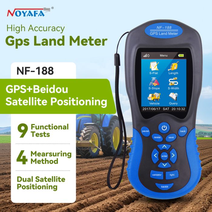
2.GPS Land Measuring Instrument NF-188
1) 2.8 inch 320 x 240 large color screen that makes more clear and visually.
2) Any shap of earth square and girth can be measured ( upland and slope inculded ).
3) Between any two points can be tested ( Length or Distance).
4) Test data , Graphics trajectory , total amount of calculation can showed on the screen.
5) Measuring method : Manual and automatic.
6) Can keep and records 99 historical data. And also can scan ,find and delete them.
7) Set up unit price according to the relative mesuring units.
8) Extra money detect , lighting and backligh functions.
9) Configure 2 pcs of 3.7V/ 2000mAh batteries , can work 8-10 hours for each battery that can save the cost for the users.
3.Land Measuring Instrument NF-188
1)Item Specifics:
2)Is_customized: Yes
3)Brand Name: Noyafa4)Model Number: NF-188
5)Place of Origin: Shenzhen.China
6)Detect range:0-999999.9 meter
7)Color: Blue + Gray
8)Measuring errors : 1-3 meter
9)Power:3.7V x 2 battery
Reviews
Write Your Own Review